Model tracks desert spread
By Chhavi Sachdev, Technology Research NewsBands, spots, rings, and stripes are patterns that show up regularly in the vegetation of relatively dry lands.
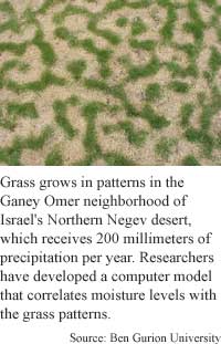
Researchers in Israel studying these plant patterns have developed a software model that predicts how the patterns form and when and how they change. The researchers have also come up with a new way of classifying arid land based on this model of fluctuation. The results could help prevent desertification and could lead to more efficient reforestation efforts.
The researchers' vegetation simulation software can replicate the entire range of vegetation patterns anywhere on earth, given information on water availability and plant aggregation, said Ehud Meron, a physics professor at Ben Gurion University in Israel.
Using statistics on biomass density, or plant life per unit area, and ground water density, the model plots how plant life will evolve over time, said Meron. "It reproduces the whole spectrum vegetation patterns observed in nature," he said.
The model takes into account basic processes such as vegetation growth rate, seed dispersal, water uptake by roots, and runoff that is not absorbed by the soil; it then plots the possibilities for different rainfall amounts and varying land gradient, said Meron.
The model will predict, for instance, whether grass that grows in bands on a slope might grow as spots on a plain, given an equal amount of rainfall, Marion said. It showed that spots of grass degrade into rings because of the strong competition for water in their center regions, he added.
The model can be used to delve into how desertified land could be made arable again, Meron said.
In some precipitation ranges, the system shows that more than one vegetation pattern can co-exist. Both bare soil and spots of grass, for example, can exist in an area with 50 to 200 millimeters of rainfall.
These areas are more vulnerable to desert expansion due to a lag effect, said Meron. "Vegetation that is killed off by a drought will not recover even when it is followed by rainy years that bring the precipitation to the original level," he said.
"Imagine we initially have a region with 100 millimeters rainfall covered by spots. Imagine now there's a drought, the rainfall drops to 25 millimeters... and the land becomes bare [because] spots cannot survive below 50 millimeters" of rain, Meron said. Even if a few years later the precipitation is back to the initial level of 100 millimeters, the bare soil will remain because the transition to spots occurs at a higher threshold 200 millimeters, he said. "This is desertification: an irreversible decrease in bioproductivity caused by a climatic change."
Because there is a clear demarcation of the range within which certain vegetation grows, the results can be used to classify land in order to better manage it, said Meron.
The researchers plan next to test the model's predictions on two kinds of perennial grass, said Meron.
The work is interesting, said Ning Zeng, a professor of meteorology at the University of Maryland. While other scientists have applied simple equations to other vegetation models, "I'm not aware of any such work in... desert vegetation," he said.
"Being able to explain these kinds of patterns in terms of simple equations is a good thing," he said. But applying abstract mathematical formulas to nature can be difficult, Zeng said. Sometimes the parameters are too sensitive and sometimes there is too much statistical noise in nature, he said.
In future incarnations of the model, the researchers will split the water variable in two separate inputs: over-land and soil water, Meron said. This "will give a more accurate description of vegetation states in circumstance where runoff water [plays an] important role," said Meron. The model should be ready to make these new predictions within five or six years, he said.
Meron's research colleagues were Jost von Hardenberg, Moshe Shachak, and Yair Zarmi at Ben Gurion University. They published the research in the November 5, 2001 issue of Physical Review Letters. The research was funded by the Blaustein Institute for Desert Research of Ben Gurion University and the Israel Science Foundation.
Timeline: 5-6 years
Funding: Government; University
TRN Categories: Applied Computing; Data Representation and Simulation
Story Type: News
Related Elements: Technical paper, "Diversity of Vegetation Patterns and Desertification," Physical Review Letters, Nov 5, 2001.
Advertisements:
January 9, 2002
Page One
Sunlight turns water to fuel
Search method melds results
VR tool keeps line of sight in hand
Laser pulse penetrates glass
Model tracks desert spread

News:
Research News Roundup
Research Watch blog
Features:
View from the High Ground Q&A
How It Works
RSS Feeds:
News
Ad links:
Buy an ad link
| Advertisements:
|
 |
Ad links: Clear History
Buy an ad link
|
TRN
Newswire and Headline Feeds for Web sites
|
© Copyright Technology Research News, LLC 2000-2006. All rights reserved.